Leaving Little Current about noon we faced into a strong east wind that made the first part of the leg a little rough. We went to anchor on the west side of a large bay called Mudge Bay which is on the south side of the North Channel. The next morning we lowered the dinghy and went into Kagawong. This picture shows the town and the municipal dock where we tied up the dinghy.

Kagawong was supposed to be a quaint village that still retains some of the charm of an old logging village which along with pulp production was its primary commerce 100 years ago. The pulp was shipped to factories that made pages for the Sears-Roebuck Catalog.
Our first stop was the Anglican Church that is famous for its nautical decor.
The interior of the church uses boat artifacts in decorating the sanctuary. The lectern is the bow of a boat wrecked many years ago in the North Channel. A boat steering wheel is on the wall and other pieces were used inside.

We then walked up a tree shaded path towards Bridal Vail Falls. Part way up, near what may have been an old mill or power plant building, I took this picture of the foam pattern in the still water on a side channel.

Bridal Vail falls had two falls. We could walk behind the curved falls on the left. The small pool in front of the falls was deep enough to swim in.

After swimming in the pool I decided to see what the falling water felt like on the right side falls. The force was incredible. I could not keep my head under the full force of the water even momentarily.
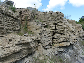
 As we walked backed to the dinghy by the main road we passed two interesting sights. One was this rock formation showing the sedimentary layers. The other was the Chocolate Works chocolate shop. We loaded up on speciality chocolate again.
We had intended to stop at the Benjamin Island which have beautiful reddish rock formations. There were several boats in the recommended anchorages and the wind was going to going to be a little higher the next day, so we pressed on to another anchorage at Shoepack Bay.


Shoepack Bay was surrounded on three sides by high walls. It was very quiet and protected the night we anchored with no other boats around. The next morning with rain and wind it looked like this.

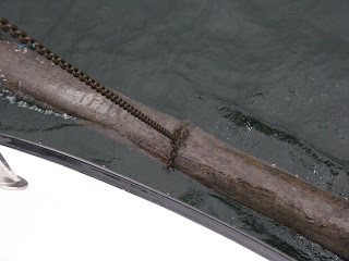
As Kaye was pulling up the anchor (in the rain) she yelled that there was a tree on the anchor. I thought see meant just some branches but as I came forward I saw this 12-15 foot long log that our chain had looped around almost exactly in the middle of the log. Apparently, as our boat had swung around during the night we had looped the chain around this partially floating deadhead log. The anchor was still about 30 feet below this loop.
So after contemplating what to do, I got the dinghy down and went to the bow. By prying with a screwdriver and pulling with my hands eventually I was able to work the chain off one end of the log and allow us to raise the anchor. We lost about an hour doing all this. But we had plenty of time to head out to our next anchorage in Robinson Bay just past Devils Horn point on the north side of Cockburn Island (which we later found out was pronounced Co-Burn Island.) This was our last stop in Canada.


No comments:
Post a Comment