Monday, September 7, 2009

Middle Michigan August 27 - Sept 3


Leland Municipal Harbor was undergoing rebuilding. Michigan has invested in a series of Harbors of Refuge down the coast to provide spots for boaters to get off the lake in case of severe weather and large waves. Money to provide these facilities come from boat license fees and fuel taxes.


Years ago Leland was a busy fishing port. Fish shacks lined the Leland River leading out into Lake Michigan. Now most commercial fishing has died out and the fish shacks have turned into boutiques for tourists. A typical fishing boat is one with high sides and a covered cockpit.


As we walked around Leland there was a park with a garden and a center circle. The center circle was sponsored by a local group called the Leelanau Conservancy which had sponsor plaques all around the circle. It seemed similar to the use of brick for contributions, instead they used specially made glazed plaques with individual designs and the contributors names on them.


How do the boys in Fishtown pick up their girl friends for a date? Well in a Amphicar of course! That way you can cruise the lake or make the "drag" in town.


We were surprised to see this "car" come cruising into the Leland. I think it just motors up the boat ramp onto land and drives off.


We ended August 27 at Leland with calm waters and a pretty sunset.


There is a huge variety of lighthouses on Lake Michigan. This one was attached to what looks like a barn.


We are now into the sand hills of Michigan. Almost all the west coast of Michigan will look like these sand dunes. This picture may have been the Sleeping Bear Dunes National Lakeshore.


Next stop was the Municipal Dock in Manistee. The town has about 6,500 residents. The downtown had an interesting museum of Manistee history with many artifacts for previous centuries. The downtown buildings were interesting. James Earl Jones first began acting at the Ramsdell Theater in Manistee. Manistee was originally important for its logging and salt production industry. Logging has stopped but there are still three factories on Lake Manistee, including Morton Salt.


There was a Glik's store for shopping for clothes and a grocery store near. We were disappointed that the tourist trolley that we walked to does not run on Saturday.

Also at the Manistee Municipal Marina were the New Zealand family, the Ashbeys on the trawler Pearl. We invited them over for snacks and spent several hours finding out about their previous boating adventures in canal boats in England and Europe, the home schooling, and their Great Loop adventure.


We were tied up on a wall downtown the Manistee River. The river is the inlet to Lake Manistee and freighters come up the river to drop off or pick up loads at the salt factories. This freighter passed within 80 feet of our boat as the captain threaded the needle up the river. Later that night he returned going out but was about 8 feet higher in the water indicating they had dropped off a load of some bulk material.


We spent one night anchored in Lake Muskegon and dinghyed into a marina to catch the tourist trolley. We also saw the American Tug 41 Emerald Lady of our friends Dick and Nancy White tied up at the marina while they were away in Kentucky. The trolley tour showed us that there were many attractions to visit in Muskegon.


As we were leaving the Lake Muskegon inlet we were followed by the catamaran ferry Lake Express starting a high speed trip across the lake to Milwaukee.


More sand cliffs heading south to Grand Haven our next stop.


We stayed two nights at the Grand Haven Municipal Marina. We walked to the Train Station museum and learned about a fountain, sound, and light show that happened every night of the summer through Labor Day. We sat on the back cockpit of our boat both nights and were able to hear and watch the fountains across the river move up down and around in time to music as colored lights played on the water. It was a great show.


The next day we rented a car at Grand Haven, bought groceries at WalMart and headed off to Muskegon. A quick stop for Barbecue Ribs and pulled pork at Mr. T's Barbecue in Muskegon gave us strength for touring. Next stop was the Great Lakes Naval Memorial and Museum. The museum displayed information mostly about submarines, because outside was the WWII sub Silversides credited with sinking 23 Japanese ships, the third most of any US Sub, and the only one of the three still preserved.


The tour through the sub was interesting. This particular galley table is famous because an emergency appendectomy was preformed by Pharmacists Mate (similar to a Navy Corpsman) Thomas Moore. With no experience in surgery other than observing some Moore removed the appendix of sailor George Platter using some tools fashioned from kitchen ware and saved his life. This event was depicted in the movie Destination Tokyo.


Next was one of two remaining LST's from WWII. This Landing Ship Tank (LST) was involved in several landing in Europe including Salerno and Normandy.

The huge bow doors open to reveal a large area for storing vehicles to be deposited on the enemy beach. Crew and army quarters were near the stern of the boat. It is one of the few boats with an anchor on the stern (used to pull the boat back off the beach.)


Rich lumber barons created some intriguing homes of Victorian architecture. This is the Hume House.


This is the Hackley House. The Hackleys donated huge sums to the City of Muskegon for a library, school, park statues, and other facilities.


Northern Michigan August 21 - 26

We arrived at Drummond Island on August 21st, two months and two days after entering Quebec. Drummond Island was originally part of Canada and was fortified after the War of 1812, but was given to the US after the Treaty of Ghent and is now part of Michigan. This is where we cleared US Customs which went smoothly. The marina notified the Customs Officer who came to our boat asked a few questions, checked our decal (which seems to be just revenue for the government to pay for customs personnel), and filled out a form. We were done and taking down our quarantine flag in less than 10 minutes. After a night at the Drummond Island Yacht Haven we headed back out into Lake Huron for a trip to Mackinac Island.


We entered the harbor and after settling in went for a walked down the main street. Quite of bit of the downtown is like a beach tourist trap but there are interesting parts such as the ostentatious Victorian houses and Inns.


The next day we took the traditional horse drawn trolley tour. Kaye gave me scathing reviews later for not taking any pictures of the horse drawn vehicles since that is the hallmark of Mackinac Island - no motor powered vehicles allowed! But I did take pictures of the first stop on our tour, the butterfly house.

Inside the glass hot house were butterflies from all over the world with plants that are their favorites. The butterflies would land on you and you had to be inspected before you went out to keep from carrying a "guest".


Of course the highlight for me was the last stop which was Fort Mackinac (which you seasoned travelers know is pronounced Mack in augh not Mack in ack.) The forts exhibits exceeded my expectations and included in one exhibit a hologram of an 1840's doctor and a doctor from this century telling how they did or would now treat various illnesses or injuries.


The fort is up on the tall hill with an excellent view of the harbor.


This view shows the Mackinac Island State Harbor in the foreground the main street on the far right and four of the many ferries that ply the waters around the island. One companies ferries are designed to shoot up a stream of water behind which I assume is just for show. Two shown are catamarans.


After two nights we left the harbor heading west and caught sight of the famous Grand Hotel.


Within a couple hours the Mackinac Bridge came into view. This bridge built in 1957 connects lower Michigan to the upper part called the UP or upper peninsula. The total length is 3.64 miles and the suspension portion is 8,614 feet making it the third longest suspension bridge in the world after being surpassed by two others in 1998.
There is more information about the bridge at this web sit.
http://hunts-upguide.com/st__ignace_mackinac_bridge.html


We came down the Eastern shore of Lake Michigan and turned up into the bay containing Harbor Springs. There was a neat wooden tour boat coming out as we made our turn.


We had some nice days although a little cool while we were there. The first night a local community band played a concert on the grass next to our marina.


The downtown was upscale. Many boutiques, cafes and restaurants lined the street. I had to sample a malted milk drink at one cafe to see if it matched the delicious one I had in Hyde Park, NY.


Kaye liked the glass blown items at this shop, the Boyer Glassworks. She found a round paper weight with glass flowers embedded that showed marvelous craftsmanship so we made a purchase after watching the owner actually do glass blowing.


From Harbor Springs we went down the coast to Charlevoix. This was the first harbor that had the typical breakwall of large rocks forming a safe path into the town harbor. Every harbor the rest of the way down Michigan had this same type entrance usually with an old lighthouse at the entrance.

We anchored in the NW corner of Lake Charlevoix just east of the main Charlevoix harbor and dinghyed into town. We located a grocery store and a movie theater and decided to go for the 4:30 showing of Julie/Julia which was very good.

As we were leaving the dinghy dock we saw the Trawler "Pearl" with the Ashbey family (John, Phillippa, Alice and Lloyd) from New Zealand aboard. We had first talked to John at Port Severn while waiting to lock through. We had noticed his boat had a home port of N. Zanesville, OH which was about 30 miles from Coshocton Ohio where we used to live so we talked to him then. We soon found out they had bought the boat in Florida with the goal of doing the Great Loop. At Charlevoix we checked in with them and I told them about the Carp Barrier problem in the canal/river south of Chicago. We had seen the news on the American Tug web site a day or two before.


We left Charlevoix the next morning passing what I believe to be modern facsimiles of the famous stone houses of national known local designer, Earl Young. Earl Young's houses employed rough-hewn stones and curvilinear roof forms to blend with the landscape. They have very rounded storybook shapes.


I thought these little wooden boats parked in front of one of the "Earl Young" type houses were neat.


Sunday, September 6, 2009

North Channel August 19 - 21


Leaving Little Current about noon we faced into a strong east wind that made the first part of the leg a little rough. We went to anchor on the west side of a large bay called Mudge Bay which is on the south side of the North Channel. The next morning we lowered the dinghy and went into Kagawong. This picture shows the town and the municipal dock where we tied up the dinghy.


Kagawong was supposed to be a quaint village that still retains some of the charm of an old logging village which along with pulp production was its primary commerce 100 years ago. The pulp was shipped to factories that made pages for the Sears-Roebuck Catalog.


Our first stop was the Anglican Church that is famous for its nautical decor.


The interior of the church uses boat artifacts in decorating the sanctuary. The lectern is the bow of a boat wrecked many years ago in the North Channel. A boat steering wheel is on the wall and other pieces were used inside.


The stained glass windows continued the marine theme.


We then walked up a tree shaded path towards Bridal Vail Falls. Part way up, near what may have been an old mill or power plant building, I took this picture of the foam pattern in the still water on a side channel.


Bridal Vail falls had two falls. We could walk behind the curved falls on the left. The small pool in front of the falls was deep enough to swim in.


After swimming in the pool I decided to see what the falling water felt like on the right side falls. The force was incredible. I could not keep my head under the full force of the water even momentarily.


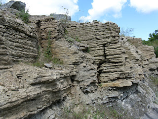
As we walked backed to the dinghy by the main road we passed two interesting sights. One was this rock formation showing the sedimentary layers. The other was the Chocolate Works chocolate shop. We loaded up on speciality chocolate again.


With our booty of chocolate we went back to the boat and headed north in early afternoon.


We had intended to stop at the Benjamin Island which have beautiful reddish rock formations. There were several boats in the recommended anchorages and the wind was going to going to be a little higher the next day, so we pressed on to another anchorage at Shoepack Bay.


Shoepack Bay was surrounded on three sides by high walls. It was very quiet and protected the night we anchored with no other boats around. The next morning with rain and wind it looked like this.


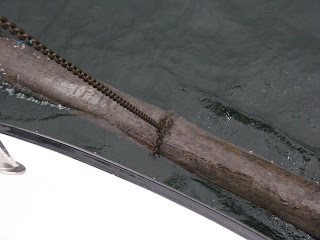
As Kaye was pulling up the anchor (in the rain) she yelled that there was a tree on the anchor. I thought see meant just some branches but as I came forward I saw this 12-15 foot long log that our chain had looped around almost exactly in the middle of the log. Apparently, as our boat had swung around during the night we had looped the chain around this partially floating deadhead log. The anchor was still about 30 feet below this loop.

So after contemplating what to do, I got the dinghy down and went to the bow. By prying with a screwdriver and pulling with my hands eventually I was able to work the chain off one end of the log and allow us to raise the anchor. We lost about an hour doing all this. But we had plenty of time to head out to our next anchorage in Robinson Bay just past Devils Horn point on the north side of Cockburn Island (which we later found out was pronounced Co-Burn Island.) This was our last stop in Canada.